Drone surveying service - メーカー・企業4社の製品一覧とランキング | イプロス

Drone surveying serviceの製品一覧

1~6 件を表示 / 全 6 件

表示件数

[Case Study] Kajima Corporation

Introducing a case study that established the best balance between in-house production and outsourcing!

We would like to introduce a case where Kashima Construction Co., Ltd. implemented our "Kumiki." Traditionally, outsourcing was the mainstream approach, but there was a challenge in that nothing remained in-house as knowledge or expertise. After the implementation, we were able to establish the best balance between in-house operations and outsourcing, resulting in significant effects in both competitiveness and the efficiency and productivity of operations. [Case Overview] ■ Challenge: Nothing remains in-house as knowledge or expertise ■ Effects - Successfully balanced the improvement of operational efficiency and productivity with retaining necessary knowledge and expertise within the company - Enabled remote work instructions from headquarters and branches, allowing for swift and effective execution of operations *For more details, please download the PDF or feel free to contact us.

  • Other measuring instruments
  • Other Software
  • Surveying
  • Drone surveying service

ブックマークに追加いたしました

ブックマーク一覧

ブックマークを削除いたしました

ブックマーク一覧

これ以上ブックマークできません

会員登録すると、ブックマークできる件数が増えて、ラベルをつけて整理することもできます

無料会員登録

From Aerial Photographs to 3D Data! [Introduction to Drone Surveying]

Drone surveying converts aerial photographs into 3D data! It is particularly useful for larger areas.

Conventional topographic surveys have required a vast amount of time and cost. Drone surveying is particularly useful for larger areas as it converts aerial photographs into 3D data. By incorporating survey control points (reference points) into the photographs, it is possible to set the scale and convert the data to match the coordinate system of construction drawings. We also offer aerial video shooting, which is not typically visible. Our company has manufacturer-certified dedicated staff who handle everything from "flight planning" to "shooting flights" and "editing results" in a consistent manner. 【Flow from Aerial Photography to Analysis】 ■ Pre-planning ■ Flight plan creation ■ Installation of control points ■ Drone flight shooting ■ Photo synthesis ■ Analysis work *For more details, please refer to the PDF document or feel free to contact us.

ブックマークに追加いたしました

ブックマーク一覧

ブックマークを削除いたしました

ブックマーク一覧

これ以上ブックマークできません

会員登録すると、ブックマークできる件数が増えて、ラベルをつけて整理することもできます

無料会員登録

Drone surveying services

Using a high-end model for long-distance and high-density measurement! We provide high-precision 3D surveying.

Our company offers surveying services using drones in various locations, including civil engineering sites. Photogrammetry involves extracting feature points from a series of continuous aerial photographs using image analysis software to create 3D data, allowing for cost-effective measurements. Additionally, laser surveying can separate data from the surface of trees and the ground within the range of laser light, even in forested areas. 【Features】 ■ Photogrammetry - Cost-effective and high-precision surveying is possible in bare land. ■ Laser Surveying - Accurate measurements can be taken down to the ground beneath the trees. ■ Photo + Laser - 3D data can be created by combining point clouds with photographic images. *For more details, please download the PDF or feel free to contact us.

  • Other measuring instruments
  • Drone surveying service

ブックマークに追加いたしました

ブックマーク一覧

ブックマークを削除いたしました

ブックマーク一覧

これ以上ブックマークできません

会員登録すると、ブックマークできる件数が増えて、ラベルをつけて整理することもできます

無料会員登録

Drone surveying service "Kumiki"

Easy, fast, and inexpensive! A cloud service that allows you to check the terrain of the site!

"Kumiki" is a drone surveying service that automatically generates 3D, elevation difference, and orthophoto images, providing an environment where you can easily and quickly check the terrain on-site at any time. By simply uploading images, orthophotos, DSM, and point cloud (3D) data are automatically generated. There are no tedious tasks such as parameter settings required from the customer. With various measurement tools implemented in an easy-to-use and visually clear web interface, anyone can easily perform calculations for distance, height, area, and volume. 【Features】 ■ Automatic processing with no setup required ■ Easy to perform various analyses ■ Compatible with both specialized and commercially available drones ■ Automatically generates 3D, elevation difference, and orthophoto images ■ Quickly and easily check the terrain on-site at any time *For more details, please refer to the PDF document or feel free to contact us.

  • Analysis and prediction system
  • Other measuring instruments
  • Other analytical equipment
  • Drone surveying service

ブックマークに追加いたしました

ブックマーク一覧

ブックマークを削除いたしました

ブックマーク一覧

これ以上ブックマークできません

会員登録すると、ブックマークできる件数が増えて、ラベルをつけて整理することもできます

無料会員登録

[Data] KUMIKI Case Studies in the Field of Architecture

Just by uploading shooting data, anyone can automatically generate terrain data without any specialized knowledge!

This document is a collection of case studies summarizing the features of the cloud-based drone surveying service "Kumiki" and its application scenes on construction sites. It introduces an overview of "Kumiki's" drone surveying, which can automatically generate high-quality terrain data without specialized knowledge, as well as representative companies that have adopted it. Additionally, it includes specific application scenes such as land development and construction management, illustrated with diagrams and photos, so please take a moment to read it. [Contents] ■ What is "Kumiki" ■ What is "Kumiki's" drone surveying ■ Representative companies that have adopted it ■ Application scenes on construction sites ■ Case studies of "Kumiki" usage in construction ■ Introduction to the Kumiki series *For more details, please download the PDF or feel free to contact us.

ブックマークに追加いたしました

ブックマーク一覧

ブックマークを削除いたしました

ブックマーク一覧

これ以上ブックマークできません

会員登録すると、ブックマークできる件数が増えて、ラベルをつけて整理することもできます

無料会員登録

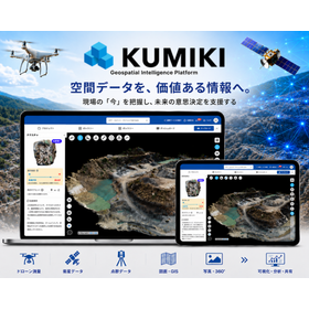
クラウド型ドローン測量サービス『KUMIKI』

ドローンで取得した画像や地形データを地図上で一元管理。測る・比べる・残す・共有する現場業務に活用可能

クラウド型ドローン測量サービス『KUMIKI』は、地形データを作るだけでなく、 取得したデータを現況把握や計測、進捗確認、情報共有などに活用でき、 建設現場の管理業務の効率化に貢献します。 ドローン画像から地形データを自動生成し、大容量のデータも軽快に 表示・操作できるほか、現場データを場所に紐づけて地図上で一元的に管理可能。 距離・面積・土量の計測や、設計データ・過去データとの比較、 現場情報の記録・共有まで行え、地形データ生成に伴う 費用・時間の削減にも貢献します。 【導入メリット例】 ◎地形データ生成にかかる費用や作業時間を削減 ◎遠隔から施工状況を確認し、現場確認・移動の時間や手間を削減 ◎距離・面積・土量の計測やデータ比較により、進捗や変化を把握 ◎本社・施主・協力会社などとの現場情報の共有を効率化 ※詳しくは資料をご覧ください。お問い合わせもお気軽にどうぞ。

ブックマークに追加いたしました

ブックマーク一覧

ブックマークを削除いたしました

ブックマーク一覧

これ以上ブックマークできません

会員登録すると、ブックマークできる件数が増えて、ラベルをつけて整理することもできます

無料会員登録